
Tour the ghost town that is Haunted Hills
Here is a self-guided tour or even a virtual tour of the Haunted Hills ghost town. Download the podcast and enjoy where ever you are, or if you have the nerve listen on location. It might feel like someone is there with you, maybe you will have a paranormal tour guide. It’s a small ghost town with a big story.
Make the most of this post
- Listen to Episode 1: Haunted Hills (you can find us on your favourite podcast player or listen below).
- See the Haunted Hills
Where are the Haunted Hills?
The Haunted Hills is off the Princes Hwy towards Yallourn between Moe and Morwell was where the ghost town Haunted Hills Road meets De Campo Road to where the Princes Highway is. Today the Haunted Hills are called Hernes Oak, and in fact, they have been named so since 1939.
Drive the Haunted Hills
Drive a loop of Haunted Hills, start in Newborough at Haunted Hills Road, then cross the overhead pass of the Princes Highway, go down McDonald’s Track until you get back to Newborough, or explore the other ghost towns and small towns by heading further into the hills.
It’s a beautiful drive.
Where are the places the Haunted Hills podcast discusses?
The podcast discusses locations, such as the Princes Highway, Haunted Hills Road, the Yallourn Cemetery, and Haunted Hills Road at the t-intersection at Bill Schultz Road.
There are many other places discussed however the buildings themselves are ghosts.
In the 1960s Hernes Oak was dismantled as there was and still is a lot of coal beneath them. The train line and Princes Highway seemed to have prevented the mining of this location.
There are places discussed in the podcast which you cannot visit, such as the Haunted Hills Hall (1934) on Hall Road, Bourke St, Haunted Hills. Nor can you visit Tyers St, Yallourn that is within the Yallourn Mine today.
There are many private residences in the Haunted Hills however one which allows visitors to stay is called Brigadoon Cottages.
A brief history of the Haunted Hills
The Haunted Hills from its history to its naming boasts a story unique to the Latrobe Valley area alone. Conquering the Haunted Hills opened up Gippsland by land, before this the first Gippsland City, Sale, due to its access to the sea and port. Located on the western side of Latrobe City, east of Moe. The Haunted Hills boasts a story unique to our area alone. The first newspaper reference of the Haunted Hills is 1866. As an obstacle to the railway moving through, also further complicated by the swamp between Koo Wee Rup and Moe. There was a path mostly traversed by drovers up until this point, most people coming to Gippsland chose steamers to Port Albert or Sale or Lakes Entrance.
The Hernes Oak Township was on the North Side of the Princes Highway, with a road over the train tracks up until about where Haunted Hills Road meets DeCampo Road. The decision to close this township occurred at the same time as Yallourn. The dismantling of the township occurred quicker as the government began buying back properties in the 1960s and the school was closed in 1975. Much of the area still exists close to the mine stopped eating into the hills further to protect the highway and train line which were well planned and not easily moved.
History of the industry at Haunted Hills
- Coal mining and electricity at Yallourn, which is less than five minutes down the road today.
- Farming
- Forestry and logging.
- Road works were continually occurring. The grader was very on the Haunted Hills – there were so many complaints about the condition of the road.
The Haunted Hills School
The Haunted Hills did not have a Department of Education school. However, there was a Sunday School Santa clause visited in 1936. The Hernes Oak school opened on the 13 August 1947, with 28 children attending under the tutelage of teacher Mrs Rookes. Two more children started the week after. The progress association is working to open up another 5 acres; however, only children between grades 1 and 2 were attending the school. They were hoping they would get a grade 3 class. The parents were grateful to have a closer school, especially since there had been particularly severe storms the week before school started.
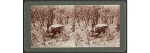
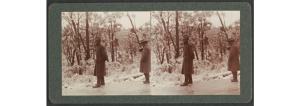
Snow tour of the Haunted Hills
Between 1935 – 1939 photographer Herbert Percival Bennett took two pictures of a significant dusting of snow on the Haunted Hills.
Haunted Hills Post Office
The Haunted Hills post office was in the Haunted Hills Station house around 1935.
When the town was renamed to Hernes Oak so was the post office.
Why is it called the Haunted Hills?
The Haunted Hills received its name by an oddity experienced before the drovers arrived and since drovers have long been replaced by cattle trucks. The oddity is a rumbling noise like phantom cattle stampeding. This kept the Gunai Kurnai people from staying on the hills after nightfall and caused many cattle losses for drovers.
Even though the Haunted Hills were renamed in 1939. Gippslanders never let go of the legend of the Haunted Hills, the name has been preserved for over 150 years. The first account I can find is an article in 1866, that discusses the rail line and the “haunted hills” as an obstruction.
The Haunted Hills quickly became the preferred method to Mount Hotham and Lakes Entrance where people would stop at a picnic area and refresh themselves. The boundary of the Rosedale Shire used to have the Haunted Hills in their bounds because they went as far to Narracan Creek in the 1870s, before the creation of the Traralgon Shire.

Tour the Haunted Hills or Hernes Oak for yourself lose yourself in the ghost town.
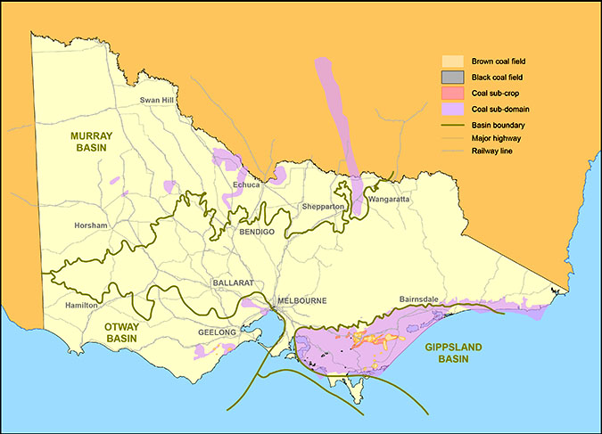
Finally, let’s tour the geology of the Haunted Hills
|
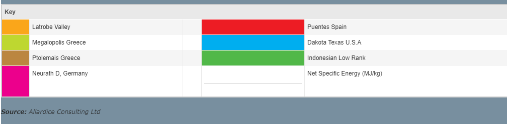
Typical Characteristics of Victorian Lignite Brown Coal
|
|
|
Energy value (net wet)
|
5.8 to 11.5 MJ/kg
|
|
Energy value (gross dry)
|
25 to 29 MJ/kg
|
|
Overburden thickness
|
10 to 20 metres
|
|
Strip ratio (coal: overburden)
|
0.5 to 5:1
|
|
Water
|
48 70%
|
|
Carbon
|
65 70%
|
|
Oxygen
|
25 30%
|
|
Hydrogen
|
4 5.5%
|
|
Ash
|
<4%
|
|
Nitrogen
|
<1%
|
|
Sulphur
|
<1%
|
|
Victorian brown coal resources
|
|
|
Total estimated brown coal in Victoria
|
430 billion tonnes
|
|
Measured brown coal in the Latrobe Valley
|
65 billion tonnes
|
|
Potentially economic brown coal in the Latrobe Valley
|
33 billion tonnes
|
Hey @theheraldsun I'd have loved to chat with Mitchell Toy and share some of my 5 years of research on the #HauntedHills including a chat I had with a #geologist about the #Gippsland #Coal Basin and its effect on the Haunted Hills. https://t.co/8A9ypsJLzp pic.twitter.com/oijVc01su9
— Tegan Dawson (@haunt_hills) December 15, 2020
There article like so many before it, in fact they used the article from 1951 to declare coal the reason.